Esri ArcGIS Desktop
- Esri ArcGIS Desktop (v10.1 or higher) supports Web Map Tile Services (WMTS).
- Esri ArcGIS Desktop (v10.1 or higher) supports Web Map Services (WMS).
- Esri ArcGIS Desktop supports Web Feature Services (WFS), providing that you have installed the Interoperability Extension.
WMTS
One-off Set-up Process
- Launch ArcCatalog
- In the Catalog Tree on the left side, locate GIS Servers and double click on Add WMTS Server.
- In the URL Box enter the required server URL. See the documentation on viaEuropa WMTS to find the appropriate service end point. Both REST and KVP are supported.
- Click the Get Layers button to test the connection. Click OK.
- The service is now listed under GIS Servers.
To add the viaEuropa service layer to ArcGIS Desktop:
- Launch ArcGIS Desktop
- Click the Add Data button
- Change "Look In" to GIS Servers
- Select the required viaEuropa service and click Add.
- Select the required viaEuropa service layer and click Add.
Note that WMTS tiles are compressed or stretched to the exact scale required in ArcGIS Desktop.
We are aware of a known WMTS (not WMS) issue with multiple Esri products. It only affects map layers projected using British National Grid (BNG) and does not affect our BNG2 or SPM WMTS map layers. The problem occurs at zoom level 7, which has a nominal scale of 1:75k. Unlike British National Grid, WMTS uses a top-left origin and zoom level 7 is slightly different because it has a different origin to the other levels. It’s just the way the tiles align as the scales supported. While WMTS does have a way of specifying origins on a per-zoom level, Esri software does not seem to support it. It’s been reported and acknowledged as bug, but it is unclear how long it will take to be resolved.
In the meantime, there is a workaround which simply removes that zoom level from the stack. When viaEuropa receives service requests, if it can detect it’s from Esri software, it applies the workaround automatically, but this is not 100% effective. So, there is a manual method too. If you place ?client=agol or ?client=arcgis on the end of the getCapabilities request (or as a custom parameter), that will force the workaround. For example, try the following WMTS getCapabilities link (replacing {id} with one of your own IDs and replacing {map} with the code of your preferred map stack):https://tile.viaeuropa.uk.com/{id}/{map}/wmts/1.0.0/WMTSCapabilities.xml?client=arcgis
When using this WMTS end-point, take a look at the zoom levels reported and check that level 7 (1:75,000) is no longer being displayed.
WMS
One-off Set-up Process
- Launch ArcCatalog
- In the Catalog Tree on the left side, locate GIS Servers and double click on Add WMS Server.
- In the URL Box enter the required server URL. See the documentation on viaEuropa WMS to find the appropriate service end point.
- Click the Get Layers button to test the connection. Click OK.
- The service is now listed under GIS Servers.
To add the viaEuropa service layer to ArcGIS Desktop:
- Launch ArcGIS Desktop
- Click the Add Data button
- Change "Look In" to GIS Servers
- Select the required viaEuropa service and click Add.
- Select the required viaEuropa service layer and click Add.
WFS
One-off Set-up Process
- Launch ArcCatalog
- In the Catalog Tree on the left side, locate Interoperability Connections and double click Add Interoperability Connection.
If you can't see this option, you may not have the Interoperability Extension installed.
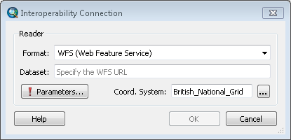
- In the Format box, type "WFS" and hit enter.
- In the Dataset box, enter the WFS URL. See the documentation on viaEuropa WFS to find the appropriate service end point.
- Set Coord. System to British National Grid by entering 27700 into the search dialogue that appears when clicking on the ... button adjacent to the search box. Select British National Grid and click OK to return to the Interoperability Connection dialogue.
- Click the Parameters button set set the WFS parameters:
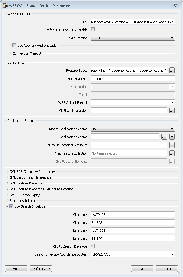
- Click the ... button next to the Feature Types box. Choose the layers from the list that you wish to access:
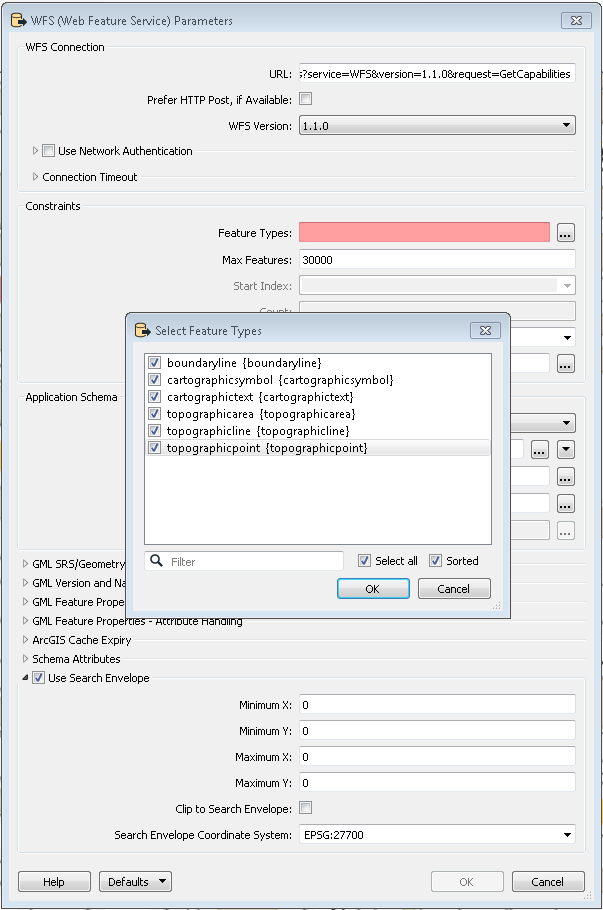
- Tick the Use Search Envelope check box and ensure that the Search Envelope Coordinate System is set to British National Grid (EPSG:27700)
- Click OK.
- Click OK.
- The connection is now listed under Interoperability Connections.
- The WFS layers are listed under the WFS connection and can be added to your map.
- You can right click the connection and choose Rename to give it a name that reflects the feature types you have selected.
To add the viaEuropa service layer to ArcGIS Desktop:
- Launch ArcGIS Desktop
- Click File > Add Data menu
- Change "Look In" to Interoperability Connections
- Select the required viaEuropa WFS connection and click Add.
- The layers you set up above to be available from the connection can be added to your map.