QGIS
WMTS
viaEuropa can delivers maps to QGIS (v2.2 or higher) as a Web Map Tile Service (WMTS). The maps provided function like a locally stored raster data layer.
The viaEuropa service supports both British National Grid ("BNG", EPSG:27700) and the Spherical Mercator ("SPM", EPSG:3857).
One-off set-up process
- In the Manage Layers toolbar or under the Layer > Add Layer menu, click on "Add WMS/WMTS Layer".
- In the “Add Layer(s) from a WM(T)S Server” dialog box, click the New button.
- In the URL Box enter:
https://tile.viaeuropa.uk.com/xxxxx-xxxxx-xxxxx-xxxxx/mapID/wmts/1.0.0/WMTSCapabilities.xml
(Replace xxxxx-xxxxx-xxxxx-xxxxx with your own viaEuropa ID and mapID with the map layer required. e.g. m0100. See Reference/Map Inventory). - Give the service a name in the Name Box, such as “viaEuropa WMTS m0100”. Click OK.
- The service is now included in the list of WMS and WMTS servers.
To add a viaEuropa service layer to QGIS
- If not already viewing the list of available WMS and WMTS servers, in the Manage Layers toolbar or under the Layer > Add Layer menu, click on "Add WMS/WMTS Layer".
- Choose the viaEuropa WMTS using the name it was assigned when it was added. Click the Connect button.
- A list of available viaEuropa layers will be displayed. Choose the required layer and click the Add button.
- The chosen viaEuropa layer will be added to the current project. Click the Close button.
Note that tiles are compressed or stretched to the exact scale required in QGIS. For optimum viewing results, use the Tile Scale Panel tool to quickly zoom in or out whilst maintaining optimum tile resolution. This can be switched on using View > Panels > Tile Scale Panel.
WFS
viaEuropa can delivers vector maps to QGIS (v2.2 or higher) as a Web Feature Service (WFS). The maps provided function much like a locally stored vector data layer.
One-off set-up process
- In the Manage Layers toolbar or under the Layer > Add Layer menu, click on "Add WFS Layer".
- In the “Add Layer(s) from a WFS Server” dialog box, click the New button.
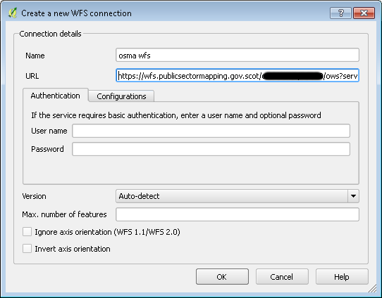
- In the URL Box enter:
http://wfs.viaeuropa.uk.com/xxxxx-xxxxx-xxxxx-xxxxx/ows?service=WFS&version=1.1.0&request=GetCapabilities
(Replace xxxxx-xxxxx-xxxxx-xxxxx with your own viaEuropa ID. - Give the service a name in the Name Box, such as “viaEuropa WFS”. Click OK.
- The service is now included in the list of WFS servers.
While version 2.0.0 WFS is supported we still recommend using version 1.1.0. If version 2.0.0 is required, please deselect 'enable feature paging' option.
To add a viaEuropa service layer to QGIS
- If not already viewing the list of available WFS servers, in the Manage Layers toolbar or under the Layer > Add Layer menu, click on "Add WFS Layer".
- Choose the viaEuropa WFS using the name it was assigned when it was added. Click the Connect button.
- A list of available viaEuropa layers will be displayed. Choose the required layer and click the Add button.
- The chosen viaEuropa layer will be added to the current project. Click the Close button.